Crete is not an island you cover from a sun lounger - it is 260 km end to end, closer to a small country, and your connectivity plan should treat it that way. Greece's three networks, Cosmote, Vodafone Greece and Nova, all operate here, and a travel eSIM connects through one of them. Heraklion, Chania, Rethymno, Agios Nikolaos and the north-coast highway that strings them together get fast, dependable 4G with 5G growing in the cities. That corridor is where most people sleep, so most of your trip is easy.
The interior is a different story. Crete's spine is serious mountain country - the White Mountains, Psiloritis, the Lasithi and Omalos plateaus - and once you leave the coast the terrain folds into valleys where coverage drops to nothing for stretches at a time. The Sfakia region in the southwest, the switchback descents to the Libyan sea, and the insides of the gorges are genuine dead zones, not weak spots. South-coast villages themselves generally have service, but the roads between them often do not. The habit that saves you: download offline maps for the whole island on day one, and load each day's route while you still have bars.
This deserves its own warning because it is a safety matter, not an inconvenience. The Samaria Gorge trek is about 16 km of descent from the Omalos plateau to the sea at Agia Roumeli, and there is no usable mobile coverage for nearly all of it - signal dies within the first stretch and reappears only at a couple of isolated points. That makes the hike committing: once you are in, help means reaching a park warden at the rest stations, not dialling 112 from the trail. Tell someone your plan, carry water, start early, and treat your phone as a camera until Agia Roumeli, where coverage returns in time to sort your ferry out.
- A hire car is close to mandatory if you want more than one corner of the island, and that makes Crete a navigation-heavy trip - live traffic on the north-coast highway, fuel stations before mountain crossings, and re-routing when a village street narrows to mirror-folding width.
- KTEL buses fill the gaps and solve the classic Samaria logistics problem (bus to Omalos, hike down, ferry out, bus back) - timetables are seasonal and live online, so checking the last connection is a data task.
- Ferry e-tickets for the south coast. Loutro and Agia Roumeli have no road access at all; you arrive by ANENDYK ferry or on foot along the coastal path. Boats run to weather and season, so checking the day's sailings before you commit to a one-way hike is not optional.
- Tap-to-pay is the norm in Greek shops and tavernas, though mountain villages, beach bars and some fuel stops still appreciate cash.
Crete has two main airports: Heraklion, the busiest, sits just east of the city, and Chania's airport is out on the Akrotiri peninsula, a short drive from town. Both have taxis and seasonal buses, and both dump you straight into the trip's first data burst - pickup instructions from the rental desk, host messages, the drive to your first stop. Install and test the eSIM before you fly so the car-hire paperwork is the only queue you face.
British Airways flies from Heathrow to both Heraklion and Chania in a little over four hours, and Manchester and Stansted to Heraklion take about four and a quarter. Crete is two hours ahead of the UK all year. The Foreign Office warns of serious ambulance shortages on some Greek islands - make sure your travel insurance covers medical evacuation - and of a high wildfire risk from April to October, when causing a fire is a criminal offence even by accident. Keep emergency alerts switched on (gov.uk, updated 11 August 2026).
Your UK plan: Greece is in every big UK network's Europe zone - included on O2, £2.72 a day on EE, £2.75 on Vodafone unless your plan has Euro Roam, and £2 or £2.75 on Three.
More than a typical Greek island, because you are effectively on a road trip: continuous navigation, ferry and timetable checks, and a camera roll that fills fast. Most travellers still land comfortably around 1GB every couple of days, but budget extra if you upload drone-free beach video or hotspot a laptop from a taverna. Top-ups are a dashboard task mid-trip, and the Greece network comparison breaks down how Cosmote, Vodafone and Nova differ once you leave the cities.
Pack for three climates. Coast: hot-weather kit plus a windproof layer for the meltemi that rakes the north shore in July and August - the Libyan-sea south coast is noticeably warmer and calmer. Mountains: real closed shoes; gorge floors are river-polished boulders and the Samaria descent destroys flip-flops and knees alike. Monasteries: Arkadi and Preveli are active religious sites expecting covered shoulders and knees, so carry a wrap. Sun protection is non-negotiable - shade is scarce south of the mountains.
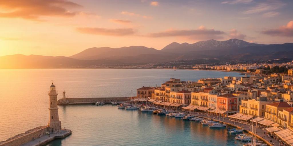
Chania's Venetian harbour is the island's postcard, and it belongs to early risers: at dawn the lighthouse doubles in the still water and the waterfront is bare tables and gulls; by ten it is café clutter. Balos lagoon's famous frame is from the overlook on the path down, not the sand - the turquoise gradient needs height - which means the rough 8 km gravel road early, or the boat from Kissamos with everyone else. Elafonisi's pink sand is real but subtle, strongest in streaks at the waterline, and August afternoons bury it under bodies. At Preveli, shoot the palm-lined river mouth from the descent path before you lose the elevation. At Knossos, the frescoes that stop people are largely reconstructions - the originals hang in the Heraklion Archaeological Museum.
The olive tree of Vouves near Chania still fruits at an estimated 2,000 to 4,000 years old, a fair symbol for an island whose oil regularly wins world awards. The kri-kri, Crete's wild goat, survives in the wild essentially nowhere else - its stronghold is the cliffs above the Samaria Gorge. And by myth, Zeus himself was born in a Cretan cave, with the Dikteon cave above the Lasithi plateau holding the strongest claim.
Greek Orthodox Easter is the event of the Cretan year - movable, usually April, celebrated hard with midnight liturgies, fireworks and lamb turning on spits in every village. Rethymno's Renaissance Festival has filled the Fortezza's Erofili theatre with music and performance most summers since 1987, though dates shift year to year, so check the current programme. The Assumption (15 August) is peak season and peak panigiri village-feast territory, and September-October brings the wine and olive harvests.
The rave is about range: nowhere else in Greece can you swim below palm trees, hike an alpine gorge, walk a Minoan palace and end the night in a Venetian port town in the same day, with the raki arriving unasked after every meal. The complaints are just as consistent: distances surprise people (Chania to the east end is a genuine half-day drive), July-August hire cars run scarce and expensive, Balos and Elafonisi draw festival-scale crowds, stretches of the north coast are charmless resort strip, and mountain driving means blind hairpins with goats standing in them. Base yourself in two places, not one, and the island makes sense.
Effectively no - coverage dies shortly after the trailhead and stays gone for almost the entire 16 km, with only a couple of known pockets. Treat the hike as offline: download the route, arrange your pickup logistics in advance, and rely on the wardens at the rest stations if something goes wrong.
Yes - the south-coast villages themselves have network coverage even though no road reaches them. The gaps are on the paths and gorges between settlements, so check ferry times and message your accommodation while in the village, not en route.
Usually, if you size it for navigation-heavy use rather than a beach week. Offline maps cut your consumption dramatically in exactly the areas where signal is thin anyway, and plans can be topped up from your dashboard if the second week runs hotter than the first.