Rogers, Bell and Telus cover Calgary, and your eSIM will use one of them. The city is comprehensively served and the network is not something you will think about. Our Alberta guide covers the reason most people come to this part of Canada - the Rockies, the parks, the wildfire season and the long stretches of the Icefields Parkway with no coverage at all. This guide is about the city those trips start from, which turns out to be considerably more interesting than a gateway, and which solved its winter in a way no other city has quite copied.
Calgary's +15 network is the largest elevated indoor pedestrian system in the world. Around eighteen kilometres of enclosed walkway, linked by more than eighty bridges, connecting most of the city centre core one storey above the street.
The name is literal. The walkways sit roughly fifteen feet above ground level, and the system is signed as +15 throughout.
It exists because of the winter. Downtown Calgary can sit at -25C with wind, and the network lets tens of thousands of people move between offices, malls, hotels and the train without going outside.
It is public, and you can walk it. Most of it is open during business hours and it is free.
Navigation is genuinely confusing. The system runs through private buildings, levels shift, and the map is not intuitive. Signal inside is generally fine, but download an offline map of the network - your phone's usual mapping will not show it well.
It empties at weekends, when the office buildings close, which is one reason central Calgary feels deserted on a Sunday.
Devonian Gardens sits inside it - an indoor park on the fourth floor of a shopping centre, with real trees, which is a very Calgary solution to February.
A chinook is a warm dry wind that comes down the eastern slope of the Rockies and hits Calgary harder than anywhere else in Canada.
It can raise the temperature more than twenty degrees in a few hours. Minus twenty in the morning and plus five by lunchtime is an ordinary chinook day, and the record swings are considerably larger.
You can see it coming. A chinook arch - a long band of clear sky under a bank of cloud along the western horizon - is the local weather forecast, and Calgarians read it instinctively.
It ruins winter plans in both directions. Ski conditions collapse, ice rinks melt, and roads go from snow to slush to ice as it passes and reverses.
Chinook headaches are widely reported. The pressure change is blamed for headaches and general malaise, and while the science is debated the local belief is universal.
What it means practically: do not pack for a fixed temperature. A Calgary winter week can genuinely span forty degrees, and layers are not a cliché here.
The city is well covered, CTrain included.
Inside the +15 network, coverage is generally good but varies building to building - some older office cores are weak.
Once you leave the city westward, this becomes an Alberta problem rather than a Calgary one: coverage follows the highway to Banff and then thins badly. Our Alberta guide covers the Icefields Parkway, where there is nothing at all for long stretches.
Kananaskis Country, the mountain area closest to the city and where Calgarians actually go at weekends, is patchy in the valleys.
The badlands east at Drumheller are covered in town and thin in the coulees.
On the prairie generally, coverage follows the roads and the towns, and the distances between them are large.
The Stampede in July is what Calgary is famous for, and our Alberta guide covers it as an event.
What is less obvious is the other eleven months. Calgary outside Stampede is a quiet, prosperous, extremely sunny prairie city with a serious restaurant scene, excellent parks along two rivers, and very little pretension.
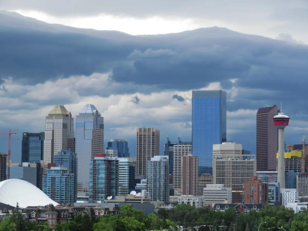
It is Canada's energy capital, and the city centre towers are head offices. That gives the city a boom-and-bust rhythm that locals will explain at length, and it is why downtown empties at five.
The neighbourhoods are where it lives. Inglewood, Kensington and 17th Avenue have the independent shops, restaurants and bars, and none of them are downtown.
The river paths are the city's best feature. Calgary has one of the largest urban pathway networks in North America, running along the Bow and Elbow rivers, and in summer people float the Bow on rafts through the middle of the city.
And the mountains are ninety minutes away, which is the fact that shapes how Calgarians spend their weekends and why the city is full of people who moved here for it.
- Calgary Transit, for the CTrain and buses - and note the free fare zone along 7th Avenue downtown, where the train costs nothing.
- Uber and Lyft, both of which operate.
- An offline map of the +15 network, which your standard mapping app handles badly.
- A weather app, checked more often here than in most cities, for the reason above.
- Alberta 511 for road conditions if you are driving to the mountains.
Calgary International (YYC) is about 17 km northeast of downtown and is the main gateway to the Canadian Rockies.
There is no rail link. The Route 300 BRT bus runs downtown for a modest fare, and Uber, Lyft and taxis all operate.
Hire cars are at the terminal, and most visitors pick one up here because the mountains are the point.
Budget 25 to 35 minutes to downtown outside peak.
Canada is a separate roaming zone from the United States - if your trip crosses the border, check your plan covers both, because North American bundles vary.
Modest for the city, where wifi is widespread and distances are manageable. The real consideration is what happens when you leave: download offline maps for the mountains before you go, because coverage stops well before the good parts do.
Layers, and more of them than you think. A chinook can move the temperature twenty degrees inside a day.
Proper winter kit from November to March - insulated coat, hat, gloves, boots with grip. And then something lighter underneath for when it swings.
Sun protection all year. Calgary is high, dry and the sunniest major city in Canada, and people underestimate it in winter with snow reflecting.
Layers again in summer, when 25C afternoons drop to single figures after dark.
Nothing formal. Calgary dresses down, and during Stampede it dresses down in cowboy boots.
The Peace Bridge, Calatrava's red helix across the Bow, at dusk with the towers behind.
The chinook arch over the western horizon on a winter afternoon, which is the most Calgary photograph there is.
The Calgary Tower's glass floor, looking straight down, with the Rockies on the horizon on a clear day.
Prince's Island Park and the river paths in autumn.
Studio Bell, the National Music Centre, whose building is worth the visit on its own.
Heritage Park, a large living-history village on the reservoir.
Inglewood's main street, for the independent shops and the record stores.
Devonian Gardens, an indoor park on the fourth floor, in the middle of February.
The +15 is the largest elevated indoor pedestrian network on earth, at around eighteen kilometres, and it was begun in the 1970s specifically to defeat the winter.
Calgary gets more sunshine than any other major Canadian city - well over 300 sunny days in a typical year, which surprises people who assume it is simply cold.
The 1988 Winter Olympics were held here, the first in Canada, and the ski jumps at Canada Olympic Park still stand above the western edge of the city.
Calgarians float the Bow River through downtown on rafts in summer, which is an entirely normal thing to do on a hot afternoon.
The city has one of the largest urban pathway networks in North America, running for hundreds of kilometres along the rivers.
And the Saddledome's roof is a genuine hyperbolic paraboloid, designed to look like a saddle, and it has been the arena since the Olympics.
The Calgary Stampede, ten days in July, which our Alberta guide covers - accommodation doubles in price and the whole city dresses for it.
Sled Island, in June, a music and arts festival spread across small venues.
Beakerhead, in September, a science-meets-art street festival.
Ski season, November to May, in the mountains ninety minutes west.
June and September are the best months in the city itself: warm, dry, long days and no Stampede pricing.
The love: Calgary is an easy, prosperous, unpretentious city with the best mountain access of any city in North America and a genuinely good food and drink scene that visitors do not expect. The sunshine is remarkable, the river pathways are excellent, the neighbourhoods are walkable and characterful, and it is a comfortable, safe and inexpensive base compared with Vancouver or Banff itself.
The complaints are consistent. Downtown is dead outside office hours, hollowed out by the energy sector's cycles and by the +15 taking people off the street. The winter is long, and the chinooks make it unpredictable rather than merely cold. There is limited conventional sightseeing - the city is a base and a place to live rather than a monument. You need a car for anything beyond the core. And most visitors leave for Banff within a day, which is understandable and means they never see the parts worth staying for.
Come in June or September, walk the +15 once for the strangeness of it, float the Bow if it is hot, and give Inglewood an evening before you drive west.
An eighteen-kilometre network of enclosed walkways one storey above downtown, the largest of its kind in the world, built so people can cross the city in winter without going outside. It is public and free during business hours. Signal inside is generally fine but navigation is confusing, so download an offline map - standard mapping apps handle it poorly.
Chinook winds, which come down off the Rockies and can lift the temperature more than twenty degrees in a few hours. Calgary gets them harder than anywhere else in Canada. Watch for the chinook arch on the western horizon, and pack layers rather than for a forecast.
Not for much of the way. Coverage follows the highway to Banff and then deteriorates sharply, and the Icefields Parkway has long stretches with nothing at all. Our Alberta guide covers this properly - download offline maps in the city before you drive west.
No. The Route 300 BRT bus runs downtown cheaply, and Uber, Lyft and taxis all work. Most visitors collect a hire car at the terminal, since the mountains are usually the reason for the trip.